Category:Amelia Island Light
Jump to navigation
Jump to search
| Object location | | View all coordinates using: OpenStreetMap |
|---|
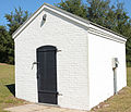
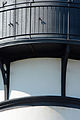
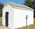
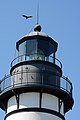
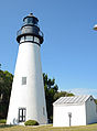
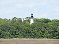
English: The Amelia Island Light is a lighthouse, built in 1838, and located on the north end of Amelia Island at the mouth of the St. Mary's River.
|
This is a category about a place or building that is listed on the National Register of Historic Places in the United States of America. Its reference number is 03000004. |
lighthouse in Florida, United States  | |||||
| Upload media | |||||
| Instance of | |||||
|---|---|---|---|---|---|
| Location |
| ||||
| Heritage designation |
| ||||
| Inception |
| ||||
| Height |
| ||||
 | |||||
Media in category "Amelia Island Light"
The following 28 files are in this category, out of 28 total.
-
 Amelia Island Lighthouse (15768775764).jpg 2,826 × 2,494; 4.28 MB
-
 Amelia Island Lighthouse (16381969781).jpg 4,000 × 2,664; 6.68 MB
-
 Amelia Island Lighthouse 1.jpg 4,032 × 3,024; 902 KB
-
 Amelia Island Lighthouse 2.jpg 4,032 × 3,024; 490 KB
-
 Amelia Island Lighthouse 3.jpg 4,032 × 3,024; 713 KB
-
 Amelia Island Lighthouse 4.jpg 4,032 × 3,024; 1.31 MB
-
 Amelia Island Lighthouse and building, FL, US (02).jpg 3,447 × 5,610; 9.85 MB
-
 Amelia Island Lighthouse and building, FL, US (03).jpg 4,000 × 6,000; 10.8 MB
-
 Amelia Island Lighthouse and building, FL, US (04).jpg 4,000 × 6,000; 10.66 MB
-
 Amelia Island Lighthouse and building, FL, US (05).jpg 5,039 × 3,996; 9.39 MB
-
 Amelia Island Lighthouse and building, FL, US (06).jpg 4,551 × 3,892; 11.67 MB
-
 Amelia Island Lighthouse and building, FL, US (07).jpg 4,000 × 6,000; 8.92 MB
-
 Amelia Island Lighthouse and building, FL, US (08).jpg 6,000 × 4,000; 10.18 MB
-
 Amelia Island Lighthouse and building, FL, US (09).jpg 4,841 × 3,987; 11.14 MB
-
 Amelia Island Lighthouse and building, FL, US (10).jpg 4,000 × 6,000; 10.08 MB
-
 Amelia Island Lighthouse and building, FL, US (11).jpg 4,000 × 6,000; 10.14 MB
-
 Amelia Island Lighthouse and building, FL, US (12).jpg 4,000 × 6,000; 10.99 MB
-
 Amelia Island Lighthouse and building, FL, US (13).jpg 4,000 × 6,000; 10.68 MB
-
 Amelia Island Lighthouse and building, FL, US (14).jpg 2,815 × 5,993; 8.04 MB
-
 Amelia Island Lighthouse and building, FL, US (15).jpg 2,701 × 5,617; 7.08 MB
-
 Amelia Island Lighthouse and building, FL, US.jpg 4,000 × 5,425; 9.63 MB
-
 Amelia Island Lighthouse view from Fort Clinch.jpg 705 × 840; 112 KB
-
 Amelia Island Lighthouse, Florida, U.S.jpg 1,887 × 3,414; 3.8 MB
-
 Amelia Island Rotaated.jpg 3,240 × 4,320; 6.29 MB
-
 Ameliaislandlh.JPG 481 × 333; 67 KB
-
 AmeliaLight1.jpg 604 × 453; 58 KB
-
 Fernandina Beach FL Amelia Island Light01.jpg 3,264 × 2,448; 1.11 MB
-
 Fernandina Beach FL Amelia Island Light02.jpg 3,264 × 2,448; 1.63 MB
.jpg)
.jpg)


.jpg)
.jpg)
.jpg)
.jpg)
.jpg)
.jpg)
.jpg)
.jpg)
.jpg)
.jpg)
.jpg)
.jpg)
.jpg)
.jpg)


Categories:
- Lighthouses on the National Register of Historic Places in Florida
- Fernandina Beach, Florida
- National Register of Historic Places in Nassau County, Florida
- Amelia Island
- Lighthouses in the United States by name
- Brick lighthouses in the United States
- White lighthouses in the United States
- Lighthouses with third order Fresnel lenses
- Landfall lights in the United States
- Lighthouses by range, 20 to 24 nm
- Lighthouses by height, 11 to 20 meters
- 18-meter-tall structures in the United States